KFTG
Denver, CO
|
Most active site: KFTG Denver, CO |
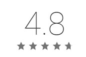
Aug 31, 2018 Since 2010, users have ranked PYKL3Radar as the highest rated level 3 radar viewer on the Android platform. We thank you all for those reviews and other great feedback. It has truly been a pleasure serving those who desired a comprehensive and customizable weather radar display platform. Customers service has always been a top priority and we have worked hard to acheive this goal. Unfortunately, Google announced changes to the Android platform which caused us to have to make some VERY tough decisions. Given the magnitude of changes imposed on developers by Google, we have determined that it is not viable to continue development or support of PYKL3Radar. Despite our desire to continue making the application available for users who have already licensed the product, Google Play's policies dictate that we must unpublish PYKL3Radar from the app store as we close our doors. We regret that Google has chosen to make these changes. Because of these externally driven factors, this will mark the end-of-life for the product. Users with PYKL3Radar already installed on their devices, should be able to continue to use the program. The program is expected to continue to function until some change from one or more of the data providers, or from the Android operating system itself, renders the functionality inoperable. At the time of closing, we were very proud to have achieved a rating of 4.8/5.0 on the Google Play store - the highest rating of any level 3 radar viewer. No further product support is available. Insight on keeping the program running as long as practical, and obtaining the final release of the app is provided here. We will, no doubt, miss our interaction with our very supportive users. Thank you again for the amazing journey. We have been asked by many groups as to whether we may be willing to release the code as open source. Unfortunately, due to the many agreements with (and potential impacts to) third parties, intellectual property concerns, and other reasons, this is not possible. Update 6 FEB 2019: The National Weather Service has made changes to their server farm thus making the program unable to acquire data from that traditional free source. It is our understanding that AllisonHouse subscribers continue to be able to view RADAR data. This is provided for informational purposes only. The program remains UNSUPPORTED. Some users have reported success with Enabling Data Providers>National Weather Service>Use HTTPS for NWS Radar then exiting the program via the back key and restarting P3 MS
|
|